|

08-13-2014, 11:25 AM
|
|
|
|
Join Date: Jul 2009
Location: Calgary
Posts: 408
|
|
 Quirk Access?
Hi folks,
just a quick post to see if anyone would care to share the best way to access Quirk Creek and approximately how long the walk is (I have a bit of a bad knee but I do want to make sure I keep moving).
Any help would be appreciated.
Happy fishing to all.
|
08-13-2014, 04:38 PM
|
|
|
|
Join Date: Jul 2013
Posts: 407
|
|
Quirk
Quirk is part of the Brook trout suppression program and you need to have a special license to fish it go to the TU Canada site to learn more There is a link on the flyfishcalgary site
|
08-13-2014, 05:00 PM
|
|
|
|
Join Date: Apr 2012
Location: Calgary
Posts: 127
|
|
Quote:
Originally Posted by kilgoretrout

Quirk is part of the Brook trout suppression program and you need to have a special license to fish it go to the TU Canada site to learn more There is a link on the flyfishcalgary site
|
This is incorrect.
You require the suppression license in order to bonk all the brookies you come across while fishing Quirk. There's nothing stopping anyone with a normal Alberta fishing license from fishing these waters, it just means that they are unable to keep any fish that they catch.
As to access, I have always fished these waters when pedalling the quirk creek / wildhorse mountain bike loop and would stop to toss flies for an hour or two along the way. I'm guessing that there is much better / closer access than the start of the MTB loop if you were coming in on foot though.
|
08-13-2014, 05:53 PM
|
 |
|
|
Join Date: Jun 2009
Location: Calgary, Alberta
Posts: 758
|
|
You can park at the cobble flats day use area and then wade across the elbow river. Then you can just follow the trail on the other side to quirk, or you can follow the elbow river downstream until you get the the mouth of quirk creek.
|
08-13-2014, 06:08 PM
|
 |
|
|
Join Date: Feb 2012
Posts: 2,302
|
|
Quote:
Originally Posted by Norman
You can park at the cobble flats day use area and then wade across the elbow river. Then you can just follow the trail on the other side to quirk, or you can follow the elbow river downstream until you get the the mouth of quirk creek.
|
Have you done this since the flood? We used to do the same thing that you are describing when going mountain biking. We'd park at Cobble and carry the bikes across the Elbow and then head towards the old Wildhorse campsite and onward! The last year we went was 2012. We'd like to go again.
|
08-13-2014, 07:36 PM
|
|
|
|
Join Date: Jun 2009
Location: Calgary, Alberta
Posts: 758
|
|
I actually haven't done it after last years flood so I really couldn't say if it's still accessible or not to tell you the truth
|
08-13-2014, 08:19 PM
|
|
|
|
Join Date: Jul 2009
Location: Calgary
Posts: 408
|
|
Thanks, guys. I hadn't even thought of the flood impact. I'm hoping to check it out in the next few days and I'll report back upon completion.
|
08-13-2014, 09:04 PM
|
 |
|
|
Join Date: Oct 2008
Posts: 2,003
|
|
Was there last week with our horses, the river is a little tricky getting across cause it now has deeper pools, and the first 200 yards of the trail is washed out then its good to go ..
__________________

|
08-13-2014, 10:30 PM
|
|
|
|
Join Date: Jul 2009
Location: Calgary
Posts: 408
|
|
Quote:
Originally Posted by blackmamba
Was there last week with our horses, the river is a little tricky getting across cause it now has deeper pools, and the first 200 yards of the trail is washed out then its good to go ..
|
Thanks very much for that info. Could be tough for me
I'm a shorty.
|
08-15-2014, 09:59 AM
|
|
|
|
Join Date: Jul 2009
Location: Calgary
Posts: 408
|
|
update
I'd heard about the brookie action and was hoping to hook into one. But a fish is a fish and in our 45 minutes of fishing, we pulled out a few of these.
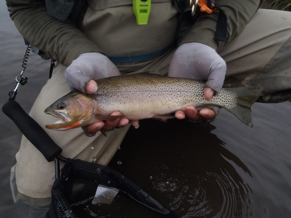
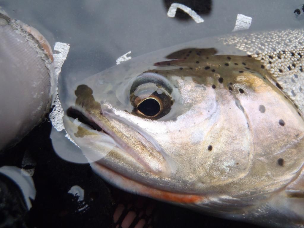
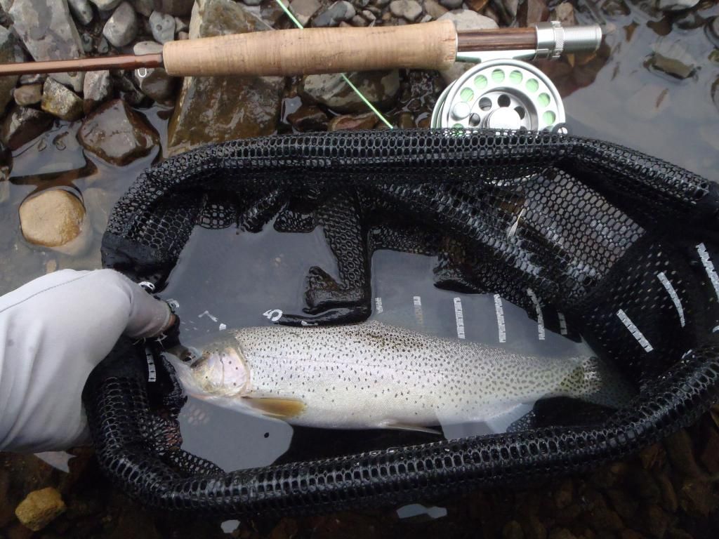
The first of our Quirk Creek Walleye!!!! Didn't even know they were in there.
|
08-15-2014, 10:17 AM
|
 |
|
|
Join Date: Aug 2008
Location: With my dogs
Posts: 4,545
|
|
Quote:
Originally Posted by commieboy
I'd heard about the brookie action and was hoping to hook into one. But a fish is a fish and in our 45 minutes of fishing, we pulled out a few of these.
|
Nice Cuts! The recovery of their population was one of the big reasons for the Brook Trout suppression project.
__________________
alacringa
"This Brittany is my most cherished possession the darndest bird-finder I have ever seen, a tough and wiry little dog with a choke-bored nose and the ability to read birds minds." -Jack O'Connor
|
08-15-2014, 10:30 AM
|
 |
|
|
Join Date: Jan 2013
Posts: 217
|
|
Quote:
Originally Posted by commieboy
I'd heard about the brookie action and was hoping to hook into one. But a fish is a fish and in our 45 minutes of fishing, we pulled out a few of these.
The first of our Quirk Creek Walleye!!!! Didn't even know they were in there. |
Just wondering if you are referring to the fish in these posted photos at walleye?
|
08-15-2014, 11:04 AM
|
|
|
|
Join Date: Jul 2009
Location: Calgary
Posts: 408
|
|
I was totally kidding. Lots of misidentification on this board with people who "KNOW" they are right and willing to fight about it. I just like poking fun at those types.
I was absolutely blown away by the size of the fish in this creek. Although I went up hoping for some brookies, the cutts were in no way a consolation prize. And these were the smaller ones. I saw bigger swimming around which were completely ignoring me.
The brookies made no appearance. Kudos to TUC on their efforts
. but I do like how aggressive they are and the way they fight. Though the biggest fish I saw in there (likely around 18") was likely a brookie.
Now if only I could pull out a sauger from that creek...
|
08-15-2014, 11:24 AM
|
 |
|
|
Join Date: Jul 2011
Location: Cochrane
Posts: 738
|
|
I hiked in from the cobble day use to the mouth of quirk creek a couple weekends ago. I fished the forested stretch all the way to the meadow at the top. All I caught was 1 cuttie, it was a bust.
|
08-15-2014, 02:52 PM
|
|
|
|
Join Date: Sep 2011
Location: Springbank A.B
Posts: 234
|
|
Quote:
Originally Posted by commieboy
I'd heard about the brookie action and was hoping to hook into one. But a fish is a fish and in our 45 minutes of fishing, we pulled out a few of these.
The first of our Quirk Creek Walleye!!!! Didn't even know they were in there. |
What is the green thing around your neck?
|
08-15-2014, 02:53 PM
|
|
|
|
Join Date: May 2012
Location: Calgary
Posts: 744
|
|
Have a look at the results for the program on T/U website. The numbers of brook trout on quirk creek is way down now. I'm assuming willow will be the same in a couple more years as it is way more accessible. Same for Waiprous creek.
|
08-15-2014, 03:40 PM
|
|
|
|
Join Date: Jul 2009
Location: Calgary
Posts: 408
|
|
Quote:
Originally Posted by kissarmygeneral
What is the green thing around your neck?
|
just a whistle. My wife and I use them to scare off bears (much better than bear bells) and to keep in touch when we're at a distance from each other.
|
08-15-2014, 04:55 PM
|
|
|
|
Join Date: Jul 2014
Posts: 76
|
|
nice pics!
|
08-15-2014, 05:53 PM
|
|
|
|
Join Date: Dec 2007
Location: Claresholm, Ab
Posts: 4,022
|
|
Nice fiss... I need to take an all day wander up Quirk sometime this fall, never been.
How far is it to the bridge?
|
08-15-2014, 06:29 PM
|
|
|
|
Join Date: Jul 2009
Location: Calgary
Posts: 408
|
|
I had put off going to this creek simply because I didn't know how to get there and all the instructions seemed spotty at best.
So, here's what you do:
Head to Cobble Flats off of Highway 66 in Bragg Creek.
The road to the parking lot eventually heads of in two direction. Stay to the right.
Cross the river (there is no bridge
you have to ford the Elbow) and aim for a destination pretty much a straight line from the parking lot. This could definitely be tough during certain times of the year. Right now, it's not a problem at all. Just choose your route wisely.
Once on the other side you should see a well maintained gravel/dirt road. This is the Wildhorse Trail. Follow it to the left for approximately 25 minutes and you'll hit the clearing where the creek lies.
It starts out pretty flat and then there is a gentle elevation gain. At about 20 minutes, you'll cross a very tiny creek running under the trail. This is not Quirk! But, there were quite a few small brookies and a couple of eight inchers swimming in one of the pools.
Continue and you'll see a sign with the Quirk regulations. It's a bit odd that at that point, there is absolutely no sign of the creek! Follow the road further and to where the treeline opens up on your left revealing a meadow and Quirk Creek winding it's way through.
It's very boggy land at this point. Waders definitely recommended as there are a lot of cows around and all that boggy water is most certainly full of their waste.
From here
. go fishing!
We went upstream for about 20 minutes and then turned around and fished the other way.
We eventually opted to go home by following the creek to the Elbow. A bit of a mistake as it took about an hour and a half (with minimal fishing) to hit the river, and at least an hour and a half to get back to the car. At the one hour point, we were convinced that we had somehow passed the parking lot and we felt totally lost (aside from the fact that we know the elbow joined up to the main highway near Ford Creek) As a result, we missed a dinner date.
If you're going to walk from the parking lot to the mouth of the creek, I would just walk along the gravel bars instead of crossing the river outright. The shoreline on the other side doesn't look all that approachable, but I didn't try it so I could be dead wrong.

|
08-15-2014, 07:09 PM
|
|
|
|
Join Date: Dec 2007
Location: Claresholm, Ab
Posts: 4,022
|
|
I found it, you only fished the lower end, there's a bridge over Quirk about 10 km up the trail. I've decided I'm too damn old and fat to fish the upper end.
Last edited by Taco; 08-15-2014 at 07:22 PM.
|
08-15-2014, 07:31 PM
|
|
|
|
Join Date: Feb 2012
Posts: 2,302
|
|
http://esrd.alberta.ca/recreation-pu...p-Aug2013A.pdf
Go to page 2. It's the map for McLean Creek PLUZ. The map doesn't show Cobble Flats very well, but in the bottom left hand corner you'll see marker 596. That's where you'll be when you cross the Elbow from Cobble. There's a bridge at 594 and another one further down the trail just SW of 606. The bridge by 606 is the off highway zone boundary. There is ( at least in 2012 there was ) a trail that heads south towards 3pt Creek. It's a good biking trail that parallels Quirk Creek for a while.
It's a good ride on a mtn bike. You'll see some off roaders, but the trail within the PLUZ is quite wide. Quad access is from McLean Creek trailhead.
Good luck.
Oh yeah, don't count on being able to see many of the markers. For whatever reason, a lot have gone missing.
|
| Thread Tools |
|
|
| Display Modes |
 Linear Mode Linear Mode
|
 Posting Rules
|
You may not post new threads
You may not post replies
You may not post attachments
You may not edit your posts
HTML code is Off
|
|
|
All times are GMT -6. The time now is 08:21 AM.
|